

On Sunday, Jan. 22, a group of hikers stood on a hillside in China Camp State Park near San Rafael watching, not wildlife thriving in the park’s salt marshes, but cars and bicycles below.
It was close to 12:30pm, and a short segment of the low-lying North San Pedro Road was covered in water, forcing visitors to brave the shallow water or turn back.
The short hike, hosted by Friends of China Camp and the San Francisco Bay National Estuarine Research Reserve, was one of about two dozen events held up and down the state’s coast last weekend in association with the California Coastal Commission’s King Tide Project.
“King tide” is a non-scientific name for the highest tides of the year. Caused by the increased gravitational pull when the earth, sun and moon align in a certain way, king tides offer a valuable teaching moment: a visible representation of the regenerative and destructive powers of water today and in the future.
Using photographs submitted by participants around the state, the King Tide Project helps “document current flood risk in coastal areas, visualize the impacts of future sea level rise in a community, ground-truth and validate climate change models by comparing model predictions with the high-tide reality, [and] serve as a living record of change for future generations,” according to the Coastal Commission’s website.
“King Tides themselves are not related to climate change, but they allow us to experience what higher sea level will be like,” the website states. “King Tides are the highest high tides of the year—one to two feet higher than average high tides, which is a good approximation of how high we expect everyday tides to be over the next few decades due to human-caused sea level rise.” In San Francisco, sea levels are expected to rise between 1.1 and 2.7 feet by 2050, according to a 2018 state study.
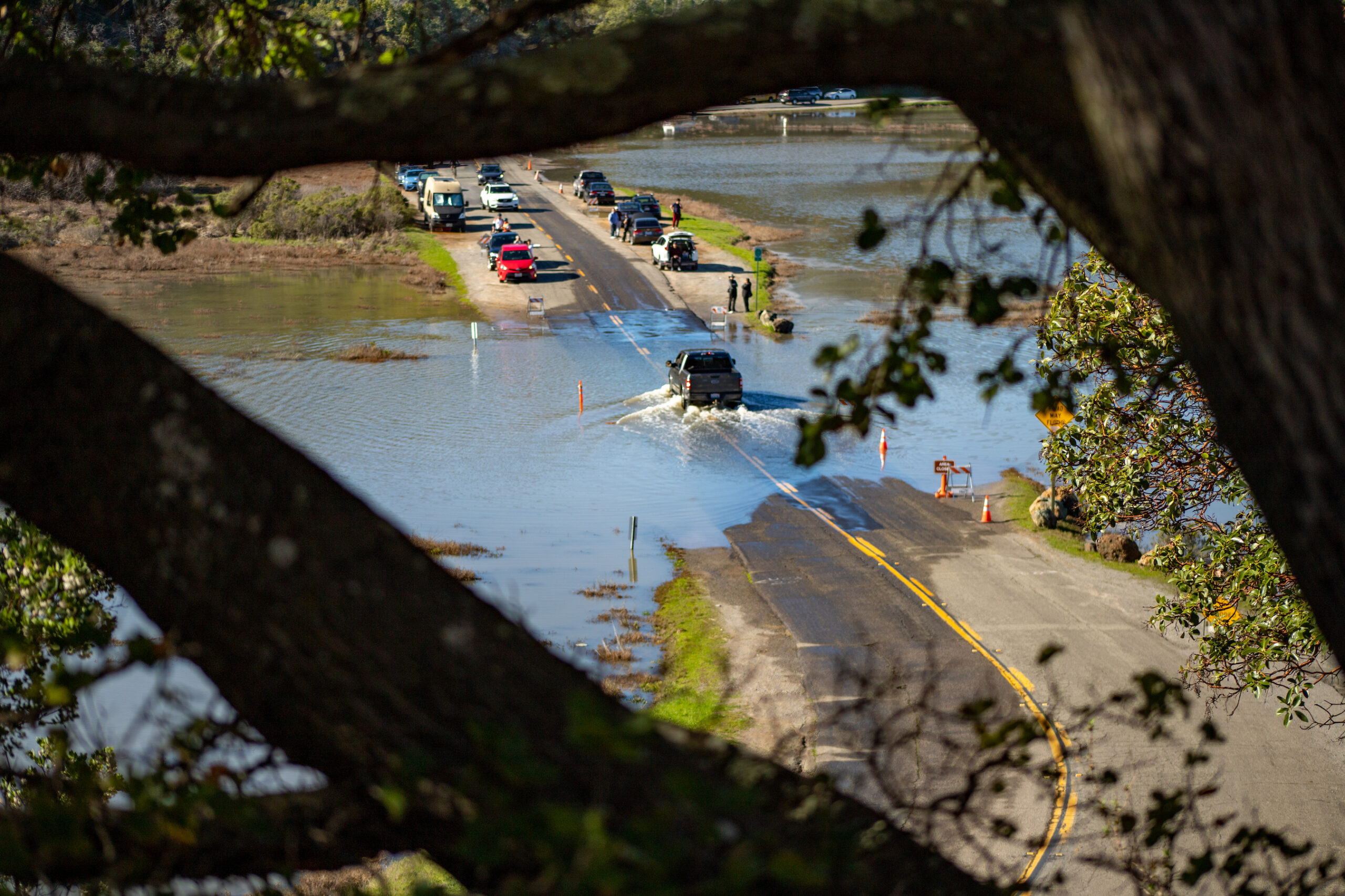
Gesturing to the flooded section of North San Pedro Road below, Dr. Stuart Siegel, the director of the San Francisco Bay National Estuarine Research Reserve, said, “With sea level rise, this will happen a bit more often. It’ll be a little deeper each time—a little more of the road will flood—and, instead of an hour or two, it will be underwater for three or four hours.”
Half an hour earlier, when the hiking group assembled in a parking lot, Dr. Mike Vasey, who led the Bay Area NERR before Siegel, dubbed the gathering a “gravitation celebration.”
Then, adopting the role of the earth, Vasey recruited participants to act as the sun and moon. He spun in place a few times, using his hands to show the bulge of water pulled outwards as he turned to face the pretend celestial bodies once again.
“When the sun gets closest to the earth and the moon is in this new moon phase right now, it exerts the largest gravitational pull on the earth, [causing higher tides]… What’s often not mentioned is the rotation of the earth, which really has a big effect on these tides,” Vasey said.
In the Bay Area, though, untouched wetlands and salt flats, like those at China Camp, are fairly rare. Before human development accelerated in the 20th century, there were 200,000 hectares, or approximately 770 square miles, of salt marshes along the edges of the bay, according to the San Francisco Bay Keeper. Today, due to “urban development, land filling, and the construction of dikes, levees, and dams,” there are only about 13,290 hectares of marshes. Rising sea levels are a threat to the remaining areas.
In addition to offering a crucial habitat for a wide range of species, salt marshes and wetlands provide an important buffer between the ocean and nearby communities, slowing or preventing flooding. They also store carbon and other climate-heating emissions, helping to mitigate global warming.
Some 20 miles north of China Camp, the Petaluma Marsh is estimated to cover roughly 5,000 acres, making it the largest remaining salt marsh in the San Pablo Bay. On Saturday, Jan. 21, Drew Dickson, owner of Napa Valley Paddle, led a small flotilla of kayaks and paddle boards up the Petaluma River, setting off from a marina off Lakeville Highway just before the height of the tide.
Partly inspired by the King Tide Project, Dickson wanted participants to experience the might of the river—and the wildlife living in the marsh. On the way into Petaluma, the level reached about five feet below the top of a bridge. On the way out, only 90 minutes later, it had receded 1.5 feet.
From a kayak on Saturday, the river appeared to be safely below any human development, even at the height of the tide. Perhaps it’s thanks to the remaining marsh that the city was not impacted.
“Wetlands detain water, which reduces flooding and erosion downstream during major storms,” states the website of the Petaluma Wetlands Alliance, a nonprofit dedicated to education and preservation efforts. “Think of a wetland as a giant sponge lying between our uplands or cities and the major waterways that drain them, or as a sponge lying between our uplands and our cities.”
Still, king tides do cause damage in the North Bay and other parts of the coast on occasion.
In November 2020, a King Tide inundated a stranded construction barge on the Petaluma River, causing it to leak industrial fluids into the water. Ahead of last weekend’s tides, Marin County officials warned of increased flood risk in some low-lying areas. And, if this year’s King Tides had aligned more closely with the historic rain storms, water levels could have been several feet higher, making them more impactful.
The widespread impacts of the tides, paired with sea level rise projections, have caused a lot of organizations to compete for funding for mitigation projects large and small.
Back at China Camp State Park, Siegel made a pitch for funding improvements to North San Pedro Road, which floods regularly.
To start, the salt marshes on either side are increasingly rare, and although there aren’t any homes along this stretch of two-lane road, it offers emergency vehicles a backup option if other routes are out of service. And, in addition to providing park access for tourists, hikers and mountain bikers, Indigenous people who use China Camp for ceremonial purposes use the road.
Thanks to infrastructure funding set aside last year, Siegel noted that all sorts of agencies will compete for sea level rise mitigation funds during the next few years.
Unlike the highly-predictable King Tides, it’s not clear when the next infrastructure investment tide will arrive. Those are subject to political, not gravitational, forces.
King Tide photos from up and down the California coastline are available at www.coastal.ca.gov/kingtides and on various social media sites, tagged #kingtide.